Seed4Forest is a mapping application which shows the vulnerability of European tree species in future climate and recommends optimum seed sources for reforestation and afforestation.
The inputs for the application are maps of species vulnerability (species distribution models) and intraspecific universal response models based on range-wide provenance trial data.
How to use the Tool
It takes three simple steps to get to the information about forest vulnerability and seed transfer: find your location, select a tree species and get the adequate seed sources to make your forest ready for climate change.
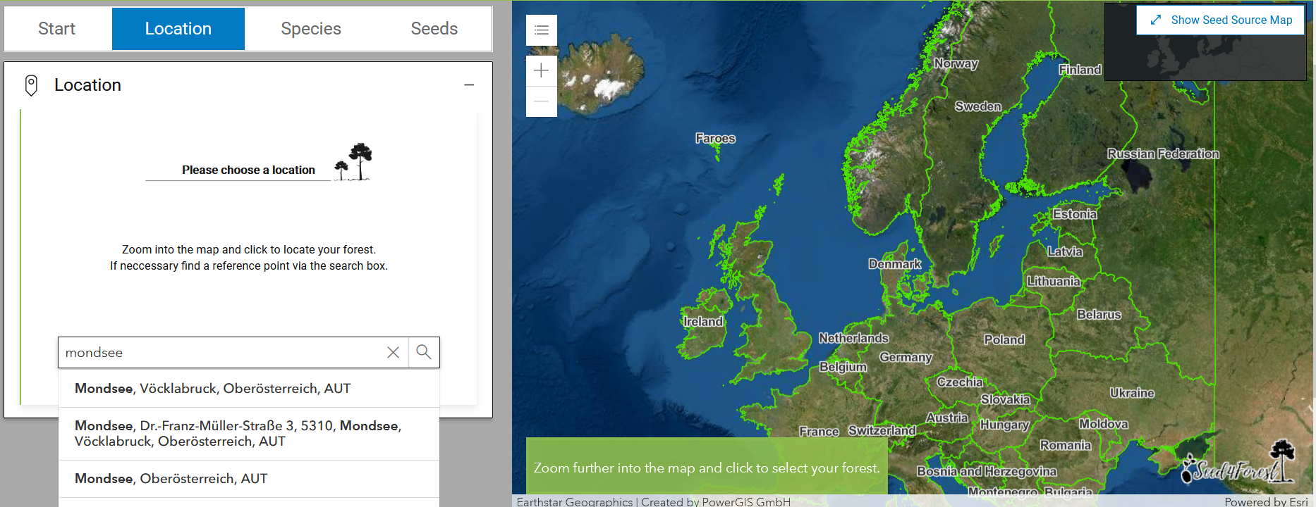
Step 1 - Location
To find the forest for which you want to obtain relevant tree species vulnerability and seed transfer data, zoom into the map and click to select your forest, or enter a reference point in the search box and then click on the appropriate location. Tips for what to do next can be found in the bottom left corner of the map (green box).
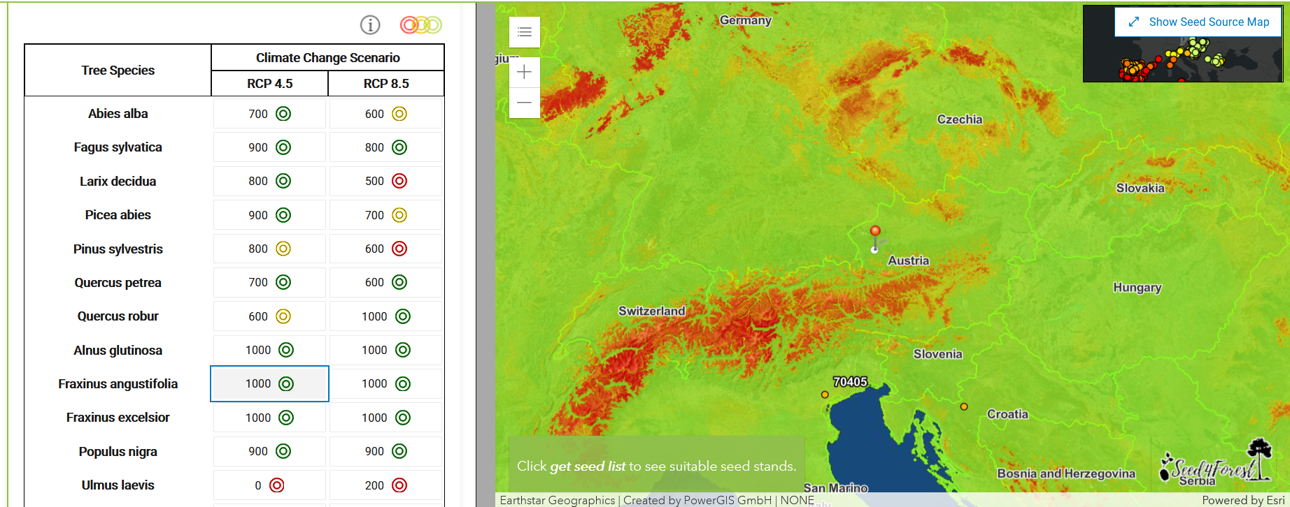
Step 2 - Species
For your selected location (red pin) the suitability of several tree species is listed for the climate at the end of the century (2080-2100) under two different climate scenarios:
- RCP 4.5 describes a scenario with reduced greenhouse gas emissions that may result in a temperature increase of 1.5-3°C in Europe by the end of the 21st century
- RCP 8.5 describes a scenario with increasing greenhouse gas emissions that may result in a temperature increase of 3-5°C in Europe by the end of the 21st century
Suitability values range from 0 to 1000, where low values depict a low probability of occurrence of each species. The coloured rings represent thresholds specific for each tree species, from green = good suitability to red = insufficient suitability.
To show the suitability of a particular species on the map, click on the value for the climate change scenario of interest. Zooming out will show you the suitability for a wider area of this species.
Step 3 - Seeds
For a list of the most appropriate seed sources for your selected tree species (ranked by distance from your forests), click on Get Seed List at the bottom of the table.
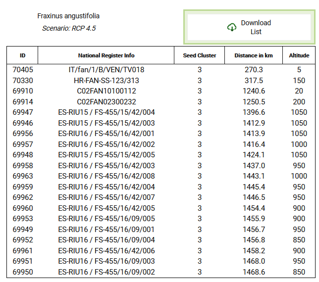
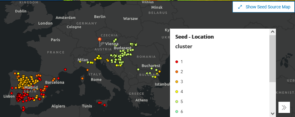
The list shows 20 adequate seed stands closest to your location, including information from the National Register (for Picea abies, Abies alba, Larix decidua, Fagus sylvatica, Quercus petraea, and Quercus robur), Seed Cluster, Distance and Altitude (Figure 5). The seed cluster refers to seed sources with similar climate, which have been grouped together and have been given a unique colour code attribute, which can be seen in the Seed Source Map in the top right corner of the tool.
The get the complete list of adequate seed sources for your selected tree species, click on the button Download list above the seed source table. The comma separated data in the text file can then be converted into a table for further processing.